
Pesisir Selatan Regency, located at the southernmost tip of West Sumatra Province, acts as a strategic intersection towards Bengkulu Province and Jambi Province because it is crossed by the West Sumatra route. South Peisisr Regency has an area of around 6,049.34 km² or the equivalent of 14.22% of the entire area of West Sumatra Province. With such an area, Pesisir Selatan Regency is the largest district in the entire West Sumatra Province. Apart from that, the coastline stretches 220 kilometers, the longest among the districts, stretching from the border with Padang City in the north to the border with Bengkulu Province in the south.1
Pesisir Selatan Regency is one of the regions in West Sumatra which is located on the west coast of Sumatra, so it is directly exposed to the potential impacts of climate change. Considering that the coastline is so long and strategic, vulnerability to climate change is an important focus in this area. So, Bappenas should include Pesisir Selatan Regency2 in Book 1 regarding the List of Locations & Climate Resilience Actions in the Super Priority (Red Zone) category in the agricultural sector.3 The increasing frequency of hydrometeorological disasters, such as floods, landslides, sea level rise, tornadoes, forest fires and droughts, some of which are caused by abnormal rainfall or extreme weather, is a clear sign of climate change.
According to data obtained from the 2020 Disaster Risk Index, nearly one million residents of Pesisir Selatan Regency live in areas that have a high risk of flooding in the central, northern and southern parts of the Regency. Meanwhile, more than 60 thousand residents live in areas prone to flash floods in the southern region in the highlands. When the dry season arrives, areas in the north face drought problems. This confirms that threats related to weather and climate dominate various disaster events that occur in Pesisir Selatan Regency.
Pesisir Selatan Regency was identified as one of the areas with high disaster risk according to data from BNPB in 2020. Of the total 15 sub-districts in this district, 12 of them were declared as areas with significant potential disaster risk.
Areas that are vulnerable to flooding in Pesisir Selatan Regency cover an area of 357,847 hectares spread over several points, as reported by the BNPB Disaster Data, Information and Communication Center in 2020. Data obtained from BNPB Pesisir Selatan Regency, noted that the incident Hydrometeorological disasters have increased from 2018 to 2022. The number of recorded events reflects this trend, with examples increasing from 16 events in 2019 to 33 events in 2021. Disaster types involving floods and landslides are of primary concern in this category.
One of the 12 sub-districts facing flooding problems is District IV Jurai.4 This condition was triggered by the overflowing of the Batang Lumpo River which resulted in 13 villages along the river being flooded. Among these villages5, Nagari Sungai Sariak Lumpo and Nagari Sungai Gayo Lumpo in IV Jurai District experienced significant impacts from flash floods. This disaster caused damage to people’s houses, agricultural land, and stopped teaching and learning activities for children in the area. Apart from that, access to businesses currently run by the community is also hampered due to damaged roads and floods that inundate the area.
In Pesisir Selatan District, the effects of climate change are often considered to be something “subtle,” but if we refer to the District Climate Vulnerability Profile and Disaster Trends in IV Jurai District, this region is identified as one of the areas that is highly affected. The report from the KLHS RPJMD Pesisir Selatan Regency 2021-2026 shows that the trend of disaster events from 2017 to 2021 is increasing.
Based on data obtained from the BMKG Climatological Station of Padang Pariaman Regency, the average temperature in Pesisir Selatan has increased by 0.017% every year, and there is also an increasing trend in rainfall by 0.03% every year. In 2019, according to data reported by BPS (2020), there was a decrease in rainfall throughout the year, but rainfall during the rainy season did not experience significant changes. However, the number of days with heavy rain is increasing, indicating that the potential for hydrometeorological disasters is increasing.
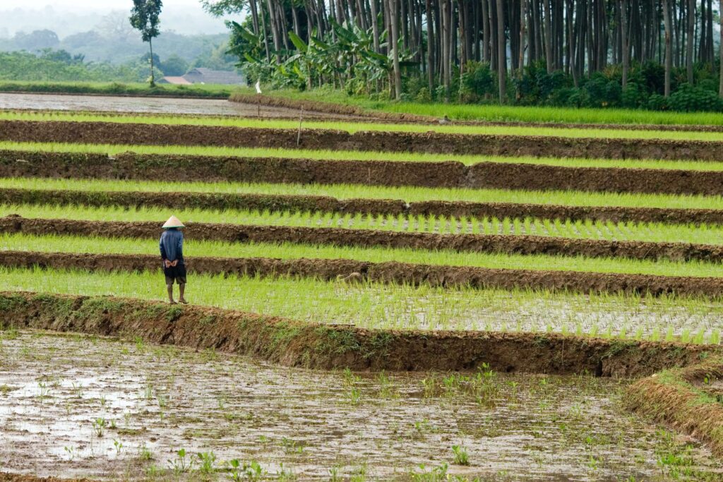
In Pesisir Selatan Regency, the agricultural sector has a very significant role in absorbing labor, especially in various nagari in this region. In general, agriculture is divided into three main categories, namely food crop farming, horticulture and plantations. In the Coastal Regency Regional Spatial Plan, agricultural land designated for food crops reaches an area of 45,291 hectares. Most of this agricultural land is used for rice cultivation, so that Pesisir Selatan Regency has succeeded in establishing itself as one of the main providers of rice in West Sumatra Province.
In 2021, it was recorded that Pesisir Selatan Regency experienced a decrease in rice production figures of 239,216 tons of GKG, which means a decrease of around 62.5 percent when compared to rice production in 2020. There are many factors that hinder the possibility of increasing production effectively. This includes scarcity of fertilizer, pest and disease attacks, non-optimal irrigation systems, and limited land for food farming, all of these factors have a significant impact on efforts to increase production. This decline reflects the increasingly visible and destructive impacts of climate change. Factors such as unstable weather, decreased rainfall, and extreme temperatures have affected the region’s ability to maintain stable rice production.
One of the factors causing the decline in rice production is the high level of land conversion in Pesisir Selatan Regency. To overcome the limited land for food farming, the Department of Agriculture has made efforts to schedule rice planting up to three times a year with the aim of achieving a higher Planting Index (IP). In this context, one of the key requirements for increasing the IP of rice cultivation is ensuring water availability throughout the year. This land conversion can be considered a response to changing environmental conditions, which in turn can exacerbate problems such as drought due to climate change, affecting the availability of agricultural land.
Pesisir Selatan Regency, with its irrigation area of 32,935.61 hectares and consisting of 265 Irrigation Areas (DI), is one of the regions facing the challenges of climate change. Of this area, 10 DI are the responsibility of the Provincial Government with an area of 7,099.64 hectares. Meanwhile, 6 DI are under the authority of the Central Government with a coverage area of around 4,928 hectares. The remainder, namely 249 DI, is the responsibility of the Regency Government with an area of 32,935.61 hectares. Of the entire irrigation area, only around 51.64% is still in good condition, while the majority experienced heavy to moderate damage.6
In District IV Jurai, which is the research location, namely Nagari Sungai Sariak Lumpo and Nagari Sungai Gayo Lumpo, the irrigation system experiences the same conditions as the irrigation system at the district level. Especially in Nagari Sungai Sariak Lumpo, there are 27 hectares of damaged irrigation systems out of a total of 53 hectares of existing rice fields. Meanwhile in Nagari Sungai Gayo Lumpo, it is estimated that around 65 hectares of irrigation systems were damaged out of a total area of rice fields of 127.5 hectares.
Nagari Sungai Sariak Lumpo and Nagari Sungai Gayo Lumpo, the agricultural sector is the first largest source of income. Of the total 774 residents of Nagari Sungai Sariak Lumpo (393 women and 381 men), there are 201 productive farmers, of which 100 are women farmers.7 Likewise in Nagari Sungai Gayo Lumpo, with a total population of 1,014 people (453 men, 561 women), 472 of whom are productive farmer households and 232 are farm worker households.8
Extreme weather changes and unpredictable rainfall patterns have had a significant impact on irrigation conditions in the region, highlighting the need for climate change-related adaptation and mitigation to ensure sustainable food security. With a population dominated by women and many of whom work as farmers, the inability to adequately face and reduce the impacts of the climate crisis will potentially result in worsening vulnerability, especially for female farmers.
Meanwhile, in the context of Nagari Sungai Sariak Lumpo and Sungai Gayo Lumpo, other identified community groups, such as children, are also part of the groups that are vulnerable to the climate crisis. This is due to children’s dependence on their mothers,9 the majority of whom are female farmers, for protection and supervision, so that they experience a higher level of vulnerability when faced with climate crisis situations, such as natural disasters or economic instability. Thus, the domestic role of women farmers in the family will increase in facing the various impacts arising from the climate crisis.
Gender roles in efforts to adapt to climate change are related to the roles of men and women in daily life in the household. One factor that plays a very important role in finding effective adaptation strategies in dealing with climate change is understanding the gender dimensions in understanding climate and climate change itself. This is because knowledge about climate and weather is the basic reaction that people will take when they are faced with climate change.10
Differences in knowledge based on gender among farmers in Nagari Sungai Gayo Lumpo are basically caused by differences in levels of understanding about the causes of climate change. There is a significant difference in the level of knowledge between men and women, with women having more limited access to education and information sources such as radio, counseling, and membership in organizations. This condition reduces women’s ability to adapt to climate change. People’s local knowledge about climate is a key factor in finding effective adaptation strategies to deal with climate change, because people’s basic response to climate change is very dependent on their understanding of climate and weather.11
Access, participation and benefits in climate change adaptation and mitigation efforts among lowland rice farmers in Nagari Sungai Sariak Lumpo show different patterns based on gender. Men tend to dominate access and control over treatment in farming, including the use of plant medicines, commodity selection, determining planting times, use of fertilizer, and treatment of harvest results. They are also more involved in physical activities such as creating rainwater reservoirs, biopores, raising land for composting waste, and clearing land.
Meanwhile, women dominate activities that are more domestic in nature, such as reusing household water and implementing the 3 M’s (Drain, Cover, Bury) to prevent mosquitoes from developing. The benefits of climate change adaptation and mitigation efforts are felt more by men. Overall, the level of gender equality in terms of access, participation, control and benefits in climate change adaptation and mitigation initiatives among lowland rice farming households in Nagari Sungai Sariak Lumpo is still at a moderate level, which indicates the existence of gender inequality, despite efforts to improve it.12
The two conditions mentioned above are also experienced by women farmers in Nagari Sungai Gayo Lumpo because actually before the expansion of the nagari, Nagari Sungai Sariak Lumpo and Sungai Gayo Lumpo were one nagari called Nagari Lumpo. The expansion was carried out in 2009 into 11 nagari.
Unfortunately, government policy in responding to the impacts of climate change, which is revealed in the 2021-2026 South Pesisir Regency RPJMD document, has not fully paid attention to Gender Equality, Disability and Social Inclusion (GEDSI). Development policies have not optimally met gender development targets which involve increasing the income of vulnerable women, understanding women’s political participation, and increasing women’s abilities in various sectors.
In addition, in the study findings in two nagari, there are gender dimensions and variables that have not been accommodated as indices for assessing vulnerability. As a result, women farmers have not received special and direct attention as a vulnerable group in development plans. Therefore, further efforts are needed to integrate the principles and adaptation activities related to climate change contained in the RAN-API into the RPJMD document. This aims to create a more inclusive and equal environment for all citizens, including women farmers who are also vulnerable to the impacts of climate change.13
References:
- Pesisir Selatan Regency Regional Regulation Number 4 of 2021 concerning the Regional Medium Term Development Plan (RPJMD) of Pesisir Selatan Regency for 2021 – 2026 ↩︎
- Districts in West Sumatra that are included in the Super Priority category (Red Zone) in the agricultural sector in Book 1 – List of Locations & Climate Resilience Actions, namely: Agam, Padang Pariaman, Pasaman, West Pasaman, Pesisir Selatan. ↩︎
- Super Priority, Top Priority and Priority Location Categories are determined based on the following criteria: 1. Super Priority: has a high potential for danger and has one of the Regional Vulnerability criteria and a high IRBI risk index; 2. Top Priority: Has a high potential for danger and has one of the Regional Vulnerability criteria or a high IRBI risk index; 3. Priority Has a high potential for danger.
District IV Jurai is a district where there are 2 nagari, namely ↩︎ - Jurai District IV is a sub-district where 2 nagari, namely Nagari Sungai Sariak Lumpo and Sungai Gayo Lumpo, are research locations for research with the title “Understanding Climate Impact on The Grassroot Communities and Rural Livelihood in Indonesia: Catalysing Changes toward Adaptation and Resilience”. ↩︎
- Nagari or Village, hereinafter referred to as Nagari or other names, is a unitary legal community and customary law community which has territorial boundaries with the authority to regulate and administer government affairs, the interests of local communities based on community initiatives, original rights, and/or traditional rights that are recognized and respected. in the Government system of the Unitary State of the Republic of Indonesia (West Sumatra Provincial Regulation No. 8 of 2021 concerning Community Empowerment and Nagari Government) ↩︎
- Revitalizing Rice Land Management Through Synchronization of the Irrigation Water Management Program, Change Project Report, Pesisir Selatan District Agriculture Service, 2022. ↩︎
- Profile of Nagari Sungai Sariak, 2021 ↩︎
- Profile of Nagari Sungai Gayo Lumpo, 2021 ↩︎
- The patriarchal culture is still strong in society, the individual most responsible for domestic affairs (reproductive roles), including caring for and supervising children is the woman/mother. ↩︎
- Kisauzi, T., Mangheni, M. N., Seguya, H., and Bashaasha, B. (2012). Gender Dimension of Farmers Perception and Knowledge on Climate Change in Teso Sub-region, Eastern Uganda. African Crop Science Journal, 20(2), 275–286 ↩︎
- Portrait of Women Farmers in Nagari Sungai Gaya Lumpo, IV Jurai District, Pesisir Selatan Regency: Climate Crisis, Gender and Vulnerability, Tanty Herida et.al., Padang, 2023. ↩︎
- Adaptation, Climate Change Mitigation and GESI (Gender Equality and Social Inclusion) Considerations for Rice Farmers in Nagari Sungai Sariak, IV Jurai District, Pesisir Selatan Regency, Tanty Herida et.al., Andalas Univ. Sociology Journal, 2023. ↩︎
- Building Resilience in Adaptation and Mitigation of Climate Change for Women and Vulnerable Groups in Pesisir Selatan Regency, Policy Brief, Institute for Community Research and Empowerment (LP2M), 2022. ↩︎